USDA Cold Hardiness Map / Zone Finder
USDA Cold Hardiness Map / Zone Finder
All plants found at your neighborhood Lowe's store are specially selected for superior performance in your area of the country. Use the USDA Cold Hardiness zone to guide you in selecting the best plants for your Canadian landscape.
Cold Hardiness
The USDA plant cold hardiness zone designation is an approximate guide of where a plant is cold hardy in the U.S. and Canada
Determination of cold hardiness is not an exact science. Many factors influence whether a plant is cold hardy in a particular area including micro climates that exist within zones. Therefore an excepted + or - one zone accuracy is accepted. For example: If a plant is listed as zone 7 it may be hardy farther north in zone 6. Use plant zones only as a general guide. If a plant is found at your local Lowe’s you can be assured that it has been selected to thrive in your area.
Some plants found at your local Lowe’s will indicate much warmer cold hardiness zone than what is found in your area. Often listed as zones 10 or 11 plants these are tropical plants used frequently as tender perennials, annuals, or seasonal tropical plants to add seasonal colour and texture to flowerbeds and containers. For instance: In Miami, Florida, a tropical Hibiscus is used as a flowering evergreen hedge, while in Chicago, Illinois, it is popular as temporary summertime colour. Less cold hardy tropical plants have become a main stay of summertime landscapes like annuals and perennials throughout the country.
How to Use the Cold Hardiness Map
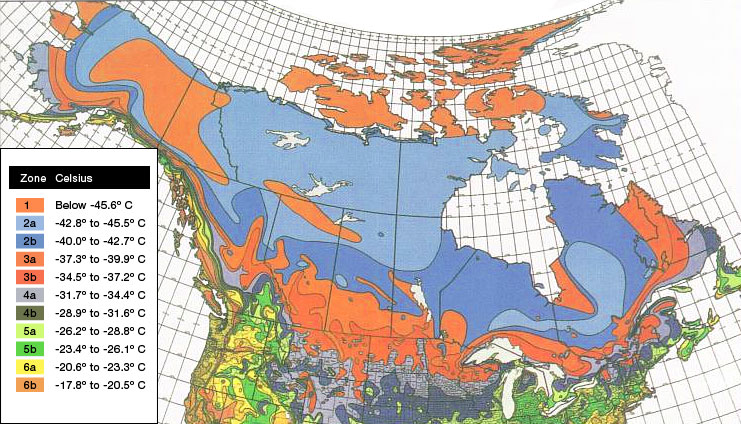
Cold Hardiness zones are based on the average annual minimum temperature in a given area of the country, with USDA Zone 1 being the coldest at minus 50 degrees F [-45.6 degrees C] and USDA Zone 11 the warmest at above 40 degrees F [4.4 degrees C].
Each of the map's coloured zones is separated by 10 degrees F [5.5 degrees C] and broken down into sub-zones A and B, separated by 5 degrees F [2.5 degrees C]. To use the map, simply locate your area and then match up the corresponding colour on the map with that on the legend.
| Zone |
Fahrenheit |
Celsius |
Example Cities |
| 1 |
Below -50º F | Below -45.6º C |
Fairbanks, Alaska; Resolute, Northwest Territories (Canada) |
| 2a |
-50º to -45º F | -42.8º to -45.5º C |
Prudhoe Bay, Alaska; Flin Flon, Manitoba (Canada) |
| 2b |
-45º to -40º F | -40.0º to -42.7º C |
Unalakleet, Alaska; Pinecreek, Minnesota |
| 3a |
-40º to -35º F | -37.3º to -39.9º C |
International Falls, Minnesota; St. Michael, Alaska |
| 3b |
-35º to -30º F | -34.5º to -37.2º C |
Tomahawk, Wisconsin; Sidney, Montana |
| 4a |
-30º to -25º F | -31.7º to -34.4º C |
Minneapolis/St.Paul, Minnesota; Lewistown, Montana |
| 4b |
-25º to -20º F | -28.9º to -31.6º C |
Northwood, Iowa; Nebraska |
| 5a |
-20º to -15º F | -26.2º to -28.8º C |
Des Moines, Iowa; Illinois |
| 5b |
-15º to -10º F | -23.4º to -26.1º C |
Columbia, Missouri; Mansfield, Pennsylvania |
| 6a |
-10º to -5º F | -20.6º to -23.3º C |
St. Louis, Missouri; Lebanon, Pennsylvania |
| 6b |
-5º to 0º F | -17.8º to -20.5º C |
McMinnville, Tennessee; Branson, Missouri |